Reference and local edits
Use approved images and targeted changes for appearance. Check fixed features after every pass; a requested preservation rule is still something to verify.

Production method / PI-WF-SPATIAL-IMAGERY / R01
Build a shared foundation. Develop the look. Check every spatial reference against the place it represents.
Creator-adopted 15 October 2026. Applies alongside the current Building and District protocols. Each image keeps its own concept, review and acceptance status.
A repeatable production path
One layout connects the aerial, bridge approach, street and view through a window.
In this schematic, the dashed lagoon outline is the reference and the pink outline is the candidate. Fade the candidate to inspect the bridge landing and building footprint. Both use the same camera.
Drift example: the bridge landing and building footprint move while the shore stays aligned.
Different real cameras need an explicit registration record. A fitted comparison can help discuss the design; it does not establish metres or certify matching geography. Geometry changes return to the layout and model.
Project example: Crown Key and West Coast reference review →
Use approved images and targeted changes for appearance. Check fixed features after every pass; a requested preservation rule is still something to verify.
Compatible workflows can condition generation on sketches, edges or depth. Record the actual controls used. Depth estimated from art does not recover measured terrain.
Render the authored model for reliable camera relationships. Preserve approved layers where exact source pixels matter, with matching perspective and occlusion.
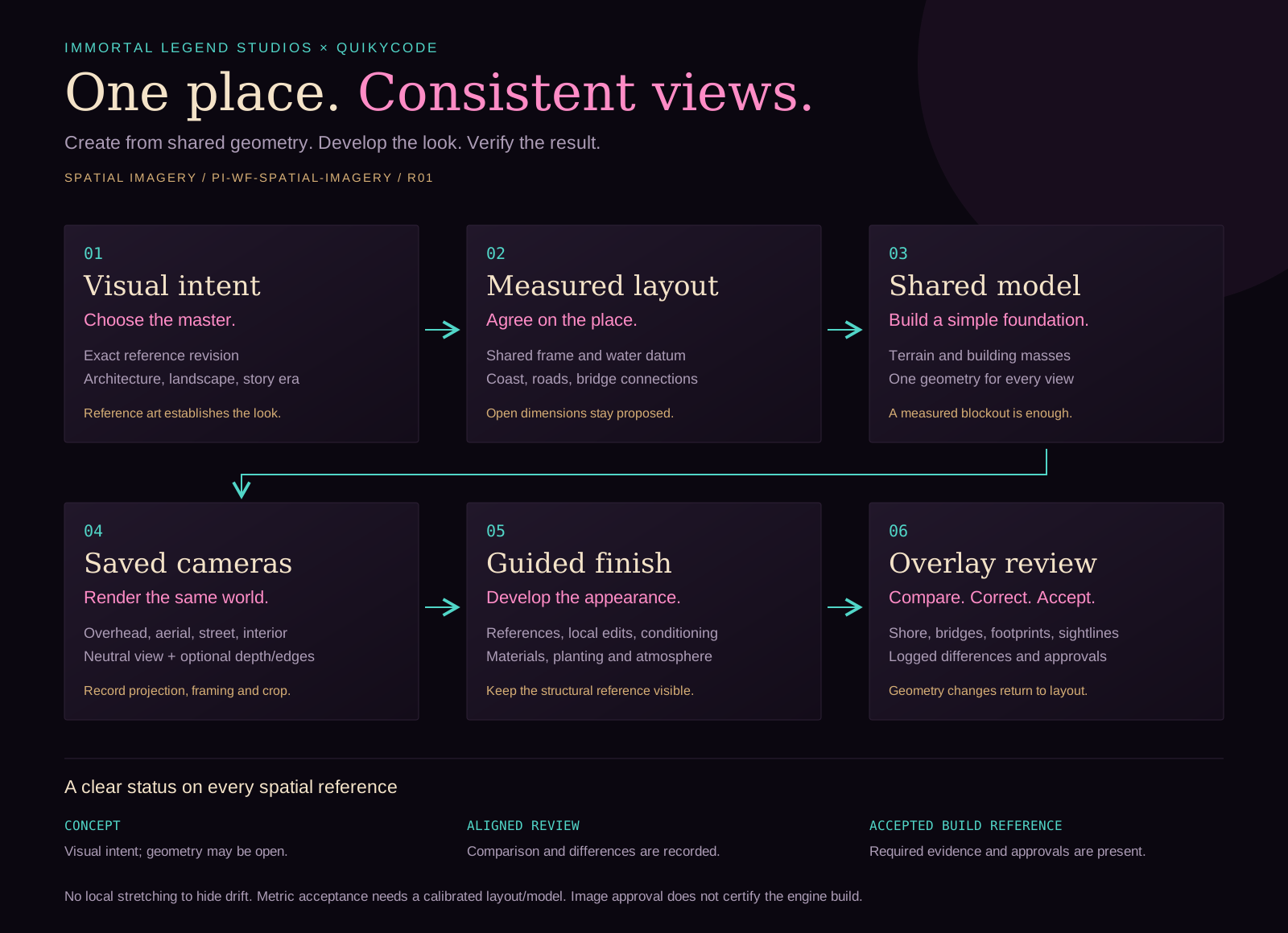
The reference IDs, measured layout, model and saved camera, neutral render, finished image, comparison overlay, difference log and scoped approvals.
The first West Coast exercise is a Crown Key–coast connection after the controlling layout and metric inputs are ready. The freestyled District 3 geography stays archived; the approved foundation is rebuilt. Construction remains paused until Legend resumes it.
The Grove preparation · Scale register · Shared-world brief · Production desk
PI-WF-SPATIAL-IMAGERY · R01 · Creator-adopted workflow · 15 October 2026
Use one authored place to produce its overheads, aerials, streets and interior sightlines. Develop the visual character through references and guided edits; verify each spatial image against the layout and camera that produced its reference. An attractive image is useful evidence of intent. A build reference also needs a traceable geometric basis and a recorded review.
Legend adopted this workflow on 15 October 2026. It supplements the current Building and District protocols resolved by production/protocols/current.json. Their issued guides and revisions remain intact. The workflow approves a method; it does not select the West Coast master, world scale, bridge span, island boundary or an Unreal implementation.
Select the exact controlling reference revision for the work area. Register composition, architecture, planting, materials, atmosphere and story era. Assign every supporting image a role: visual master candidate, material/style reference, historical comparison or view to reconcile. Log conflicts before generating another shoreline or skyline.
For West Coast, the daytime regional overview is a candidate composition master and twilight is its atmosphere companion. Crown Key sources remain comparison evidence. The fixed island-count limit is retired; the eventual approved map controls geography. Building density and population/activity are separate decisions.
Specify the shared frame, metres, north, water datum, coast, roads, parcels, building envelopes and shared connections. Give each bridge one connection record used at both ends. Separate bridge length from separation between two bridge landings. Use measured source/engine reconciliation to choose dimensions; perspective pixels cannot establish metres-per-pixel.
Record the layout ID, revision, file and hash, named controls, creator approval and open dimensions. A null or proposed value is not an accepted measurement. Legend's boat-clearance and switchback requirements carry forward; detailed datums and implementation require the connection specification. Candidate 470/940 m layout figures are not accepted by this workflow.
Create terrain, water, bridge decks, road surfaces and basic building masses from the authored layout. A lightweight blockout is sufficient: it need not contain finished meshes, interiors or foliage. Record the model revision, source units and conversion into the engine frame. Check height as well as footprint.
Use the new approved foundation. The freestyled District 3 geography stays archived on its branch/history and is replaced; it is not the base to tweak, rescale or merge into the authoritative world. Quik's construction remains paused until Legend resumes it.
Record each camera's transform, projection, lens or orthographic scale, sensor settings where relevant, aspect ratio, resolution and crop. Capture a true overhead and useful obliques from the same model. Include arrivals, shared bridge ends, Crown Key-facing streets and player-height views. For interiors, record room orientation, opening positions and floor elevation before producing exterior window views.
Keep the neutral reference render. When the chosen rendering pipeline supports them, also capture linear depth, edges and object/region masks. A model-rendered depth pass has a known geometric basis. Depth estimated from a concept image is a conditioning aid and does not recover surveyed world dimensions.
Choose the method appropriate to the change. Give every input an explicit role and list features to preserve. Use a layout render as the structural reference and approved artwork for architecture, material, planting and atmosphere. Prefer small, targeted iterations; issue new files rather than overwriting originals.
| Method | Useful control | Limit to record |
|---|---|---|
| Reference-guided edit | Existing view plus explicit requested changes | Visual guidance can still move fixed features |
| Local edit or inpainting | Selected repair region | A model's mask may be soft guidance; verify boundaries |
| Sketch or edge conditioning | Shore, road and silhouette outlines | Requires a compatible configured workflow; not a geometric guarantee |
| Depth conditioning | Relative surface depth and composition | Model compatibility and settings matter; image-derived depth is not survey data |
| Direct 3D render | Authored geometry and reproducible camera | Accuracy depends on the approved model and camera inputs |
| Layered compositing or paintover | Preserve selected source pixels and layers | Camera, perspective, occlusion and lighting must agree |
Dedicated conditioning systems such as ControlNet may improve structural adherence. Do not describe them as active merely because a prompt mentions depth or edges. Record the actual tool, model/workflow, available controls, settings and source revisions. Style adapters and random seeds do not establish cross-view geometry.
Overlay the candidate with its neutral reference using the same view, projection, aspect and crop. Inspect coast, bridge abutments, centerlines, roads, footprints, height/silhouette, water level and key sightlines. Validate both directions across shared connections. Review interiors against their openings and actual external surroundings.
Use opacity, blink, side-by-side and edge views to locate drift. Document differences and their consequence before changing the candidate. Geometry changes return to the authored layout/model and update every affected view. Appearance changes can return to the finish step.
Never fit separate features with local stretching or non-rigid warping to make a failed comparison appear to pass. Record any global crop/registration transform. The earlier three-anchor affine Crown Key comparison is qualitative: its fitted anchors agree by construction and cannot independently validate the layout. Different cameras, uncertain points and design changes all contribute to apparent offsets.
Declare tolerances for each deliverable before final acceptance. Record criterion, basis, expected value, tolerance, observed value and result. Pixel error can be reported in the comparison image. Convert it into world units only where a known projection and calibrated plane/model support that conversion. Do not assign a single metres-per-pixel scale across a perspective aerial. Pending tolerances or unverified measurements cannot be reported as a metric pass.
Some spatial images will remain concept references. Label that clearly rather than inventing accuracy to complete a checklist.
Use the view-record template and review checklist accompanying this workflow. Keep reusable planning records and graphics small and canonical. Generate website derivatives from source; do not duplicate full image libraries for each new page.
Use one Crown Key–western-coast connection view to test this method after the foundation inputs are ready. Reconcile both ends on one layout, capture the shared model view, develop its appearance and review the overlay. Then expand to Southwest streets and interior views. Plan the northern terrain broadly; detail Northwest after the connected sample. The regional art already contains mountain context but does not establish its elevations.
These describe available methods. They do not establish that a particular external pipeline is installed, configured or validated for this project.