LostSouls.world

Production / Crown + Southwest / 19 October 2026

Connected streets.
Review the drawings.

Five source boards and one matched-view comparison. Open or download each full-size PNG directly from this site.

D3 / Direction approved

Follow the visible direct road.

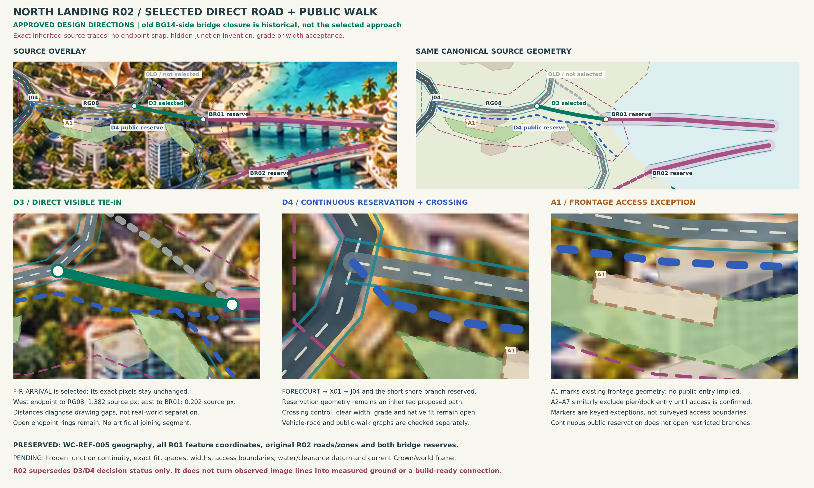
The selected approach follows the observed WC-REF-005 road. The former BG14-side closure remains historical comparison. Source-pixel joins are still unresolved; no hidden road has been invented.
D4 / Reservation approved

Keep the landing walk continuous.

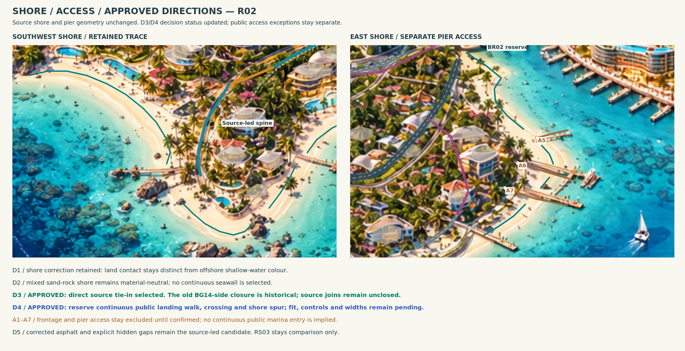
Reserve the public landing walk and crossing. Restricted frontage and pier access remain separate; detailed boundaries, grades and width/fit still need evidence.

Southwest · revised R02

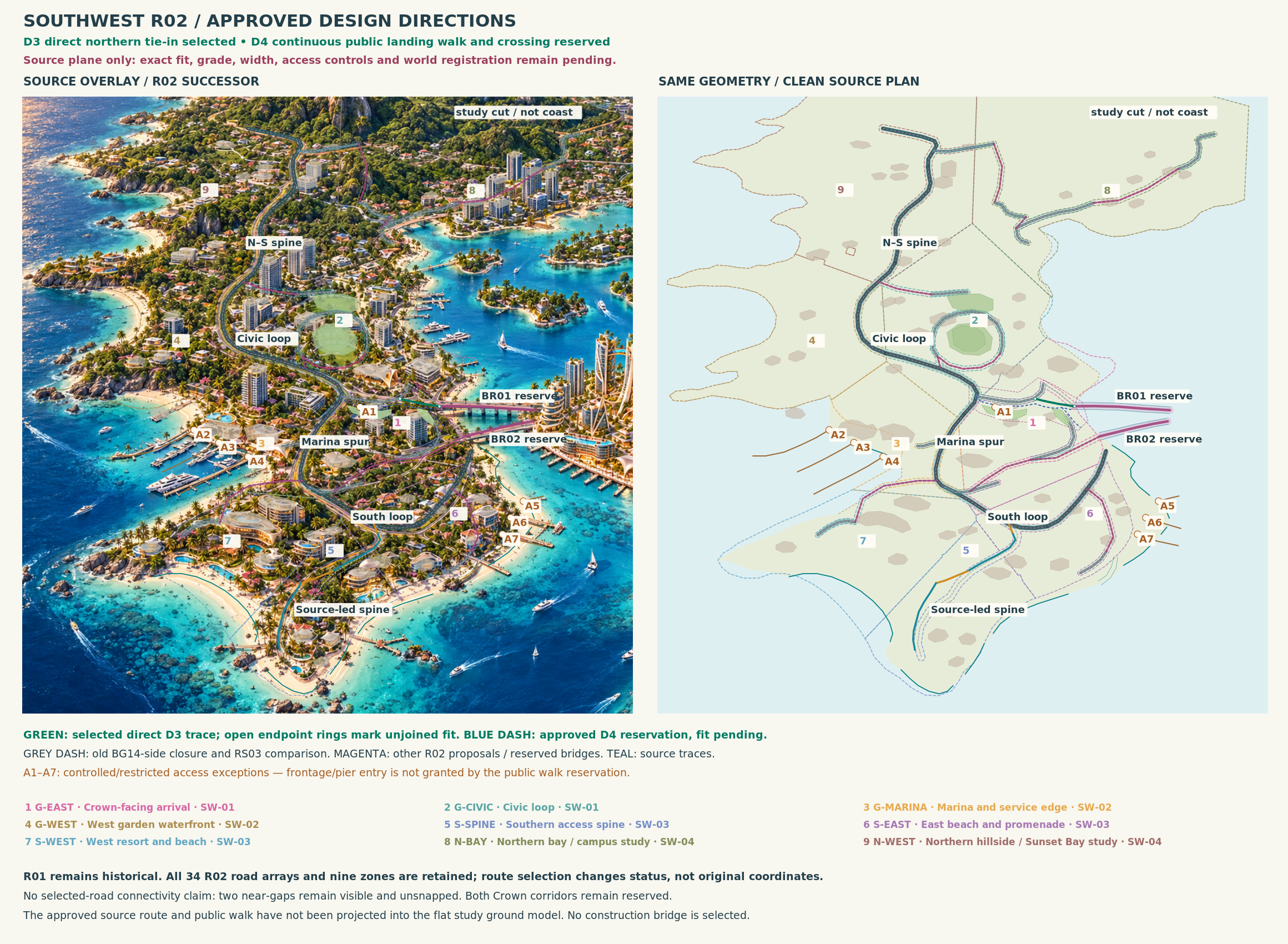
Southwest source board showing the selected direct approach and continuous landing walk with crossing, with unresolved joins and restricted access labelled.
Southwest R02 · D3/D4 direction recorded

Landing and street

D3 follows the existing direct source road. D4 reserves the public landing walk and crossing; restricted access stays separate. Source observations are not measured construction geometry.

Image integrity

2800 × 1680 px · 2,274,383 bytes

SHA-256 c90ad58faebc30543fedd4645695e349d3ce4c44639f6d86bfaf6babb21bbea7
Broad WC-REF-005 Southwest source view with streets, landing connections and the current D3/D4 direction marked.
Southwest R02 · source geography retained

Aerial foundation

The approved source geography remains intact. The direct approach is selected as source intent; connection gaps remain visible until reconciled.

Image integrity

2320 × 1700 px · 3,015,438 bytes

SHA-256 a7b998fd76fda1f22a85a67c85b8d071d9d7adb0ae588f4ede998d6278eb15be
Southwest shore review marking the continuous public landing walk, crossing and separate restricted frontage and pier access.
Southwest R02 · public walk reservation

Shore decisions

Continuous public access is reserved. Detailed fit, boundaries, widths and grades remain pending measured evidence.

Image integrity

2320 × 1190 px · 2,374,589 bytes

SHA-256 c18facca07d8efaac44b5c5eee1d174385d04b3888625f3b780be87b1b623a93

Crown Key · unchanged R03

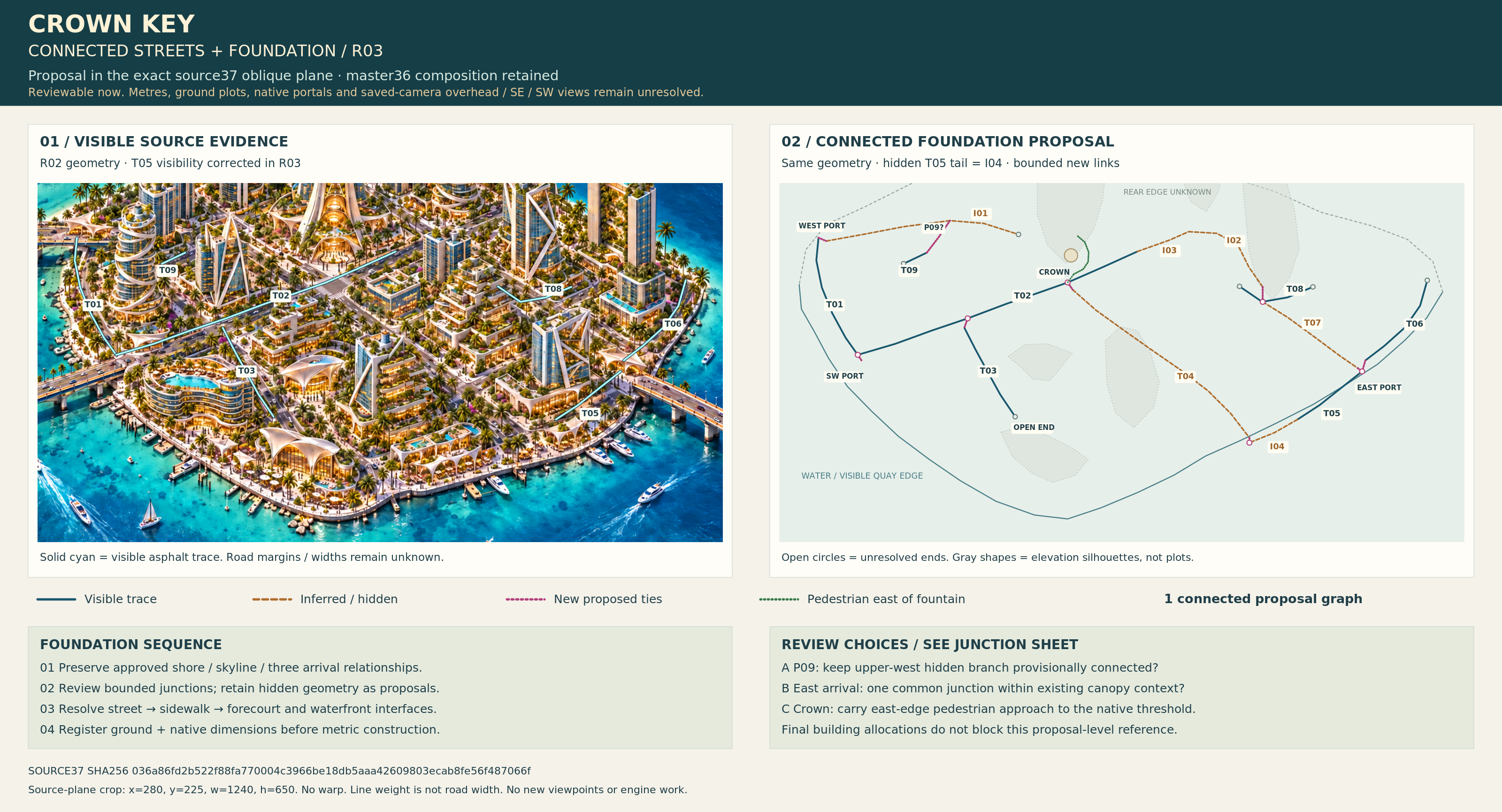
Crown Key source-plane foundation drawing with connected streets and two distinct reserved bridge corridors.
Crown R03 · unchanged

Crown connected foundation

The existing Crown source-plane board is preserved byte for byte. Both connection reserves remain; this review selects no first construction bridge.

Image integrity

3200 × 1730 px · 2,621,631 bytes

SHA-256 8b4f51ea47c2999e221af5715e5bb99c8a9bac079dec8c955c105eb2aa8da983
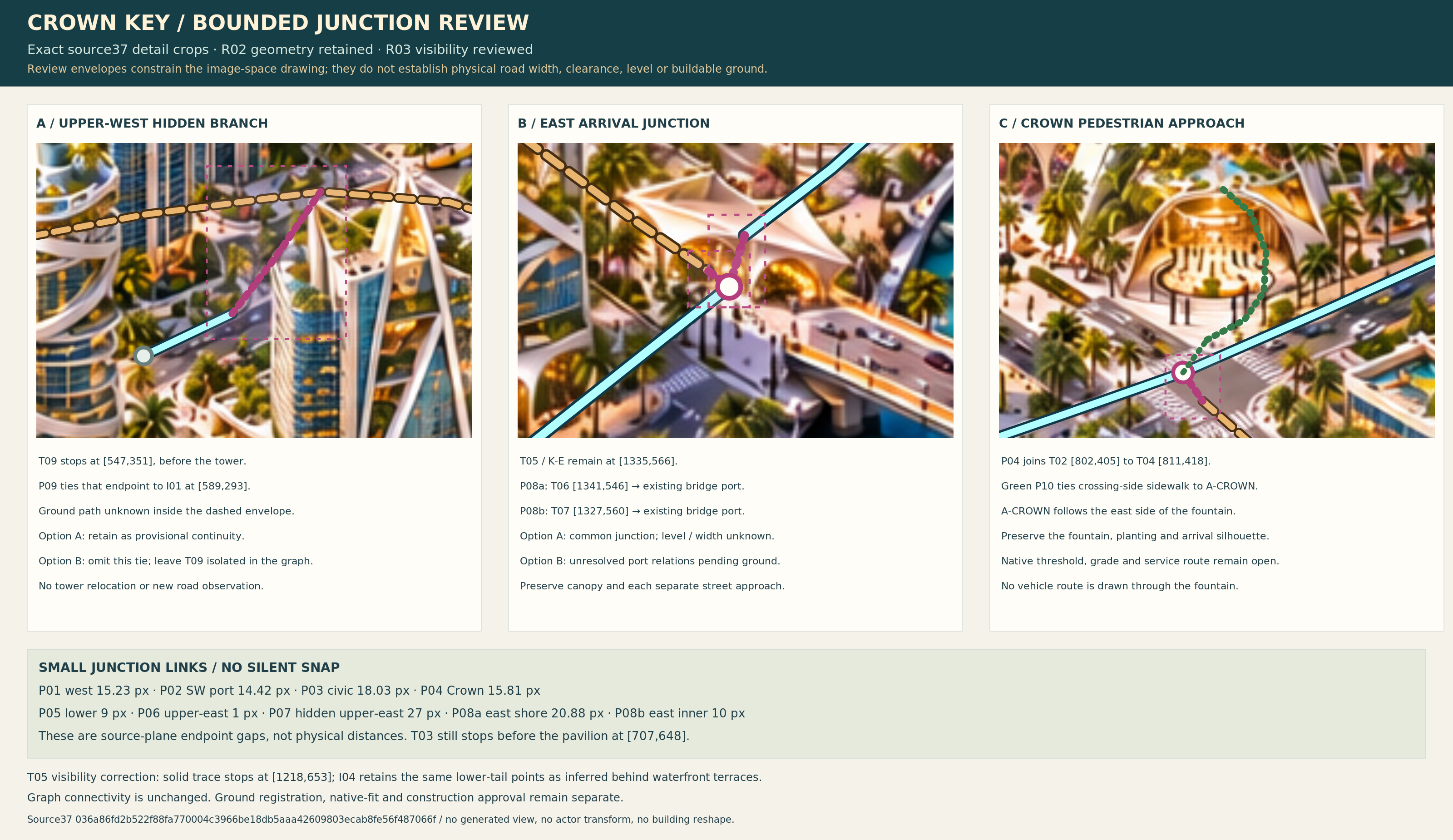
Crown Key junction detail review showing street connections and unresolved source-to-world measurement requirements.
Crown R03 · unchanged

Crown junction review

The existing junction drawing remains unchanged. World alignment, elevations, clearances and construction acceptance require separate evidence.

Image integrity

3200 × 1850 px · 2,450,639 bytes

SHA-256 2d17a365a4af0be96b60414724a4adcc794baf6bc33bccaddab9eb55f7eac75f

Matched flat study · revised R02 labels

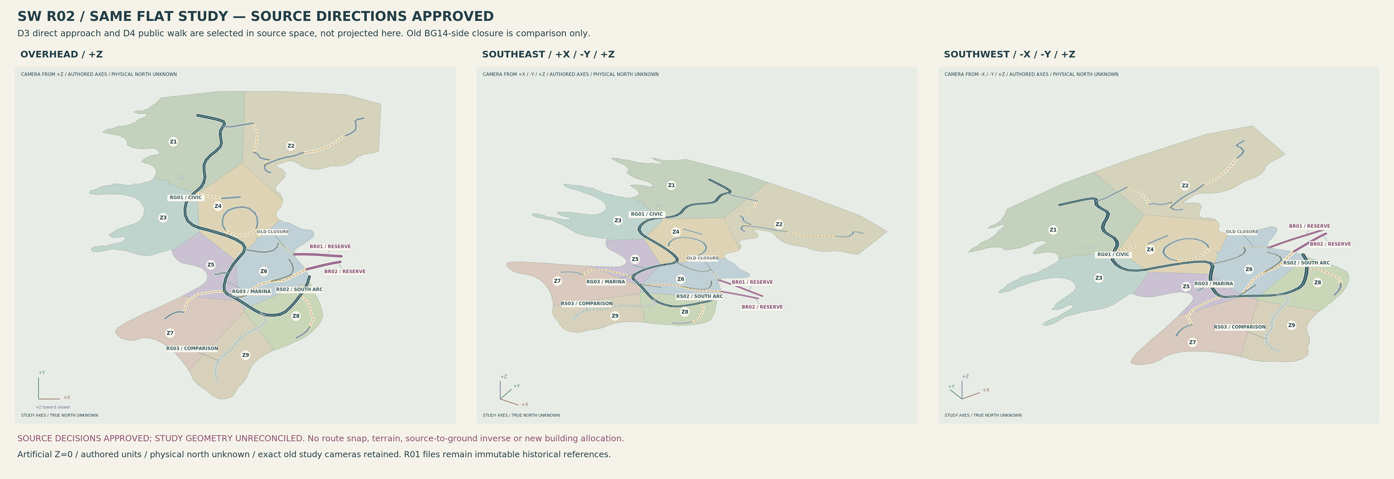
Matched overhead, southeast and southwest flat study views of one authored model, with the old closure shown as historical and the new direct source approach explicitly not yet projected.
Flat study R02 · labels updated; geometry and cameras retained

Overhead, southeast and southwest comparison

All three views retain one authored XY model, saved cameras and artificial Z=0 plane. The former closure is historical comparison. Approved D3/D4 source directions have not been projected or reconciled into this model; physical scale and geographic north remain uncalibrated.

Image integrity

4800 × 1650 px · 717,671 bytes

SHA-256 d572d3d8ae5f3bcbe5140deeeefde1da5770ba66f49dc05ba0b096af3bdcf972

What remains to be resolved

Reconcile the selected source road with the authored model; establish a shared measured frame, detailed shore and landing fit; then obtain native and route/collision/navigation evidence. Crown’s two reserved corridors remain separate. No first construction bridge is selected by this review.

Older R01 boards and their manifests remain preserved in repository history. The R02 labels above identify the current Southwest decision record.